|
|
|
|

|
|
"National Education Part 1, 4th grade"
|
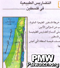
Title of map: "Natural Topography of Palestine"
The map shows all of Israel and the Palestinian areas.
It is relevant to note that the topography of surrounding countries is not shown. However, the topography of Israel is included as though it were part of the topography of "Palestine." Neither text nor map acknowledge Israel.
Map in Palestinian Authority schoolbook published in 2005, currently in use.
|
|
|
|
Jan. 1, 2010
|
|
|
|
|
|
|
|
|

|
|
1- PA schoolbooks and schools use maps erasing Israel
|
|
|

|
|
|
|

|
|
|

|
|
2- PA leaders with maps erasing all of Israel
|
|
|

|
|
|
|

|
|
|

|
|
3- Flags designate all of Israel as "Palestine"
|
|
|

|
|
|
|

|
|
|

|
|
4- PA government uses maps erasing all of Israel
|
|
|

|
|
|
|

|
|
|

|
|
5- Terror organization logos erasing all of Israel
|
|
|

|
|
|
|

|
|
|

|
|
6- PA-controlled media uses maps erasing Israel
|
|
|

|
|
|
|

|
|
|

|
|
7- PA cartoons use map that erases Israel
|
|
|

|
|
|
|

|
|
|

|
|
8- Public and private use of maps erasing Israel
|
|
|

|
|
|
|

|
|
|
|
|
|
|
|
|