|
|
|
|

|
|
"National Education Part 2, 2nd grade"
|
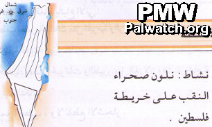
The map, which shows all of Israel and the Palestinian areas, is referred to as "Palestine" in the adjacent text instructing the student and also describes Israel's Negev desert as being located in "Palestine" .
Text: "Activity: Color in the Negev desert on the map of Palestine."
Map in Palestinian Authority schoolbook published in 2005, currently in use.
|
|
|
|
Jan. 1, 2010
|
|
|
|
|
|
|
|
|

|
|
1- PA schoolbooks and schools use maps erasing Israel
|
|
|

|
|
|
|

|
|
|

|
|
2- PA leaders with maps erasing all of Israel
|
|
|

|
|
|
|

|
|
|

|
|
3- Flags designate all of Israel as "Palestine"
|
|
|

|
|
|
|

|
|
|

|
|
4- PA government uses maps erasing all of Israel
|
|
|

|
|
|
|

|
|
|

|
|
5- Terror organization logos erasing all of Israel
|
|
|

|
|
|
|

|
|
|

|
|
6- PA-controlled media uses maps erasing Israel
|
|
|

|
|
|
|

|
|
|

|
|
7- PA cartoons use map that erases Israel
|
|
|

|
|
|
|

|
|
|

|
|
8- Public and private use of maps erasing Israel
|
|
|

|
|
|
|

|
|
|
|
|
|
|
|
|