|
|
|
|

|
|
"Geography of Palestine, 7th grade"
|
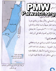
Title of map: “The Distribution of Climate Zones in Palestine”
The climate zones, shown in blue, cover the entire area of Israel, the West Bank and Gaza. Neither text nor map acknowledge Israel.
Map in Palestinian Authority schoolbook published in 2008, currently in use.
|
|
|
|
Jan. 1, 2010
|
|
|
|
|
|
|
|
|

|
|
1- PA schoolbooks and schools use maps erasing Israel
|
|
|

|
|
|
|

|
|
|

|
|
2- PA leaders with maps erasing all of Israel
|
|
|

|
|
|
|

|
|
|

|
|
3- Flags designate all of Israel as "Palestine"
|
|
|

|
|
|
|

|
|
|

|
|
4- PA government uses maps erasing all of Israel
|
|
|

|
|
|
|

|
|
|

|
|
5- Terror organization logos erasing all of Israel
|
|
|

|
|
|
|

|
|
|

|
|
6- PA-controlled media uses maps erasing Israel
|
|
|

|
|
|
|

|
|
|

|
|
7- PA cartoons use map that erases Israel
|
|
|

|
|
|
|

|
|
|

|
|
8- Public and private use of maps erasing Israel
|
|
|

|
|
|
|

|
|
|
|
|
|
|
|
|