At a PA-funded summer camp for kids, drawing of map of "Palestine" with text describing "Palestine's" borders that erases Israel
Images and text shared on the Facebook page of the National Committee for Summer Camps, which receives money from the PA Budget
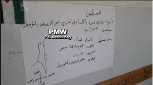
At a camp organized by the National Committee for Summer Camps, a drawing of the PA's map of "Palestine" was accompanied by the following text:
Text next to map: "Palestine
Location: The continent of Asia, eastern coast of the Mediterranean Sea
Territory: 27,009 square kilometers (the combined size of Israel and the PA areas is roughly 27,000 square kilometers -Ed.)
Borders of Palestine: Lebanon on the north
The Gulf of Aqaba and Egypt on the south
Jordan on the east
The Mediterranean Sea on the west"
Click to view bulletin
Significantly, the text's alternative "facts" reiterate the PA message that Israel doesn't exist or will not exist in the future. The description of "Palestine's" territory as 27,000 square kilometers includes the area of all of Israel in addition to the PA areas. The West Bank and Gaza together are 6,220 square kilometers. The description of "Palestine's" borders is also wrong, as it is Israel that borders Lebanon and the Gulf of Aqaba.