|
|
|
|

|
|
"Geography of Palestine, 7th grade"
|
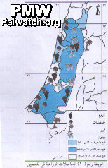
Title of map: "Agricultural Crops in Palestine"
The map shows crops located both in Israel and the Palestinian areas. By using the title "Crops in Palestine," the map makes it seem that Israel is part of "Palestine."
Map in Palestinian Authority schoolbook published in 2008, currently in use.
|
|
|
|
Jan. 1, 2010
|
|
|
|
|
|
|
|
|

|
|
1- PA schoolbooks and schools use maps erasing Israel
|
|
|

|
|
|
|

|
|
|

|
|
2- PA leaders with maps erasing all of Israel
|
|
|

|
|
|
|

|
|
|

|
|
3- Flags designate all of Israel as "Palestine"
|
|
|

|
|
|
|

|
|
|

|
|
4- PA government uses maps erasing all of Israel
|
|
|

|
|
|
|

|
|
|

|
|
5- Terror organization logos erasing all of Israel
|
|
|

|
|
|
|

|
|
|

|
|
6- PA-controlled media uses maps erasing Israel
|
|
|

|
|
|
|

|
|
|

|
|
7- PA cartoons use maps erasing all of Israel
|
|
|

|
|
|
|

|
|
|

|
|
8- Public and private use of maps erasing Israel
|
|
|

|
|
|
|

|
|
|
|
|
|
|