Embroidered maps on PA TV depict Israeli cities as “Palestine”
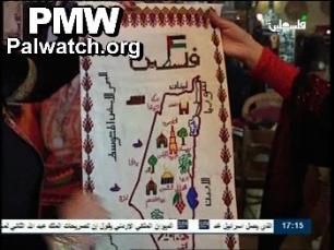
Text above the map: “Palestine”
Israeli cities on the map: Safed, Nazareth, Jaffa, Jerusalem, Bet Shean, Acre, Haifa
Palestinian cities on the map: Bethlehem, Nablus, Gaza City, Hebron, Jericho
Neighboring countries shown on the map: Lebanon, Jordan, Syria
Official PA TV program A Work of Art about Palestinian embroidery in Bethlehem.
Director of the Palestinian Heritage Center in Bethlehem, Maha Al-Saqa [showing embroidery]: “Here we have the names of Palestinian cities: Lod, Jerusalem, Nablus, Jericho, Jenin, Beit Jalah, Acre, Gaza, Tiberias, nearly all the Palestinian cities, the important cities.”
The embroidered image of a key is shown. Inside the key is a small map, the Dome of the Rock, Handala – a well-known Palestinian cartoon character who symbolizes the Palestinian refugee issue, an olive tree and a masked Palestinian.
The director of the center shows the map of “Palestine” in the embroidery. She then shows an embroidered map with the word “Palestine.”