Rajoub-led summer camper erases Israel’s existence
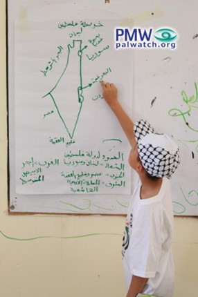
The picture shows a child participating in the PLO Supreme Council for Youth and Sports summer camps. The child is holding a drawing of the PA map of “Palestine” that presents all of Israel together with the PA areas as “Palestine” in the colors of the Palestinian flag.

The picture shows a child participating in the PLO Supreme Council for Youth and Sports summer camps. The child is drawing the PA map of “Palestine” that presents all of Israel together with the PA areas as “Palestine” on a whiteboard. At the top of the PA map is written “Map of Palestine,” and at the bottom of the map and marked on it is the following text:
“Borders of the State of Palestine
In the north: Lebanon and Syria
In the west: The Mediterranean Sea
In the south: Egypt and the Gulf of Aqaba
In the east: The Hashemite Kingdom of Jordan”
[PLO Supreme Council for Youth and Sports, Facebook page, July 19, 2023]