Palestinian Authority TV teaches children to make political map that turns all of Israel into “Palestine”
PA TV teaches children to make political map
that turns all of Israel into "Palestine"
that turns all of Israel into "Palestine"
by Itamar Marcus and Nan Jacques Zilberdik
A children's program teaching arts and crafts on official Palestinian Authority TV instructed children how to make models of "Palestine." The shape of the map of "Palestine," which was cut out of paper, included all of Israel. Adding a political message, PA TV taught the children to cover the entire model with the colors of the Palestinian flag, symbolizing Palestinian sovereignty over the whole area.
Click to view
Palestinian Media Watch has documented that the official PA maps erase all of Israel defining it as "Palestine."
The international community has criticized the Palestinian Authority for this practice. Before he was elected to office, President Barack Obama said that he viewed the use of these maps that present a world without Israel as a security threat to Israel:
"I will never compromise when it comes to Israel's security... Not when there are maps across the Middle East that don't even acknowledge Israel's existence." [AIPAC Conference, June 4, 2008]
Maps that "don't even acknowledge Israel's existence" are still the official maps in the Palestinian Authority.
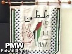 Another example of a political map that erases Israel was recently broadcast during a PA TV report on an event for youth sponsored by the Palestinian Authority Ministry of Education. A map displayed at the event likewise showed the Palestinian flag covering and accordingly erasing Israel. Above the map is the word "Palestine" and to the right of the map is the date "Nov. 15, 1988," the date that Yasser Arafat declared Palestinian statehood.
[PA TV (Fatah), April 29, 2012]
The following is the text from the PA TV program showing children how to make a model of "Palestine" erasing all of Israel:
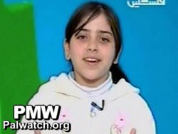 Child host: "Hello friends, today we will learn how to make a model of the map of Palestine so that we continue to remember our country, Palestine...
Of course, all my friends know how to draw the map of Palestine. Here, the map of Palestine is ready, in its historic area."
[PA TV (Fatah), March 30, 2012]